Introduction
Scenery for FSX comes in many guises, some of it mediocre, some very good, and there seems to be a never ending supply of it being released to tempt our wallets. So much in fact that I have had to have a serious rethink on how or where in the world I want to fly. It is all very well having smatterings of scenery and airports dotted around the world but there comes a time when one has to forgo some of the eye candy in order to rationalise what we keep on our hard drives. In the past I used to have half of Australia (or so it seemed), various areas of North America, the Caribbean, the Far East as well as Europe, but eventually I was forced to restrict my areas of operation because I found, as good as some of the scenery was, I simply wasn't using it often enough to justify its place on my hard drive.
With this in mind I decided to centre my operations in Europe as there are a huge amount of highly detailed airports available, and an enormous amount of scenery, a lot of which is photographic scenery, with more and more coming to the marketplace each month.
I split my flying roughly 1/3, VFR in small a/c, and 2/3, IFR in airliners, which suits my smaller area of operations, I like airliners but do not want to fly more than 2 hours without a landing, so flights from any part of northern Europe to Southern Europe are the main menu as are VFR flights in and around the UK as well as jaunts across the channel to the nearby continent.
For anyone flying like this it soon becomes evident that some scenery of France becomes obligatory and there is only one company that makes this and has been doing so for 10 years now and that is France VFR.
I first came across France VFR when using FS9. They had made some very good small regional airports with good local scenery such as Belle isle, Quiberon and Ouessant as well as Toussus le Noble near Paris, and others, and whilst they were perhaps, not to the same standard as, what we can now have from the likes of FTX, they were very much better than almost anything else available at the time. Since then they have gone from strength to strength and now produce amongst other things a very good collection of photographic scenery of the whole of France, as well as their latest product, VFR Regional, which takes photographic scenery to the next level by adding masses of individually placed 3d buildings, trees, power cable pylons, churches, wind farms, and much more, which enhances the overall experience enormously.
Most of us, I imagine, have some form of photographic scenery already installed, and FVFR already covers the whole of France, it takes its high level of detail from aerial photography, so one can see detail down to individual houses.
In their latest releases FVFR combines their photographic scenery with a special technology developed by FVFR that places literally hundreds of thousands of objects all over the scenery, they do not pretend that they represent precisely what is there in reality but it gives an interpretation of what is there in the grand scale of things and I think it works well.
In reality when one flies a small a/c across the channel to France one is immediately struck by the difference in colour the villages are from the UK and the lack of urban sprawl, and this changes from region to region, in the north the general colours of houses are grey with black roofs but in the south the houses are brightly coloured with terracotta tiled roofs and the first thing I noticed with the latest releases from France VFR is that it showed exactly this. It gives much more ambience and enjoyment to the whole simming experience as well as adding a new level of realism. It is sort of like Generation X photographic scenery, on steroids.
When flying to France from the UK, the majority of pilots choose one of three 3 main routes, most use the route from Dover (DVR) to Calais (ING) (less distance if walking on water becomes a requirement ) however the more seasoned use either Seaford (SFD) to Deauville (DVL) 62 miles or Southampton (SAM) to Cherbourg (MP) 77 miles.
For this part of the review I used the SFD-DVL route which arrives at the French coast at a town called Etretat, I have to say the similarity to reality is quite marvellous with the nearby fuel port and the cliffs leading down to the town and beach. I used the VFR photographic scenery which really comes into its own if you fly below 3000 feet , for those that prefer to fly airliners then the ordinary photographic scenery is perfectly adequate as that really starts to look realistic above 3000 feet, however if you are arriving at a destination that doesn't have a highly detailed airport installed all the land goes flat the lower you go, this doesn't happen with the VFR version, you land amongst 3D scenery.
I then took a tour of the Northern Normandy from Deauville to Rouen and up past Honfleur to Le Havre and followed the coast to Dieppe, an area I know very well and was again totally immersed in the flight so much so that I found what appeared to be meteor crater just south of the bridge over the Seine at Le Havre which I had never seen before so then went on to Google Earth to verify that it did indeed exist, and it did!
I then changed regions and using their latest product Alsace VFR I flew from Colmar to Strasbourg, a region I have never visited , however it was easy to get immersed again sightseeing along the river to the old town with its red roofs and on into the hills with small hamlets in the valleys, most enjoyable. In some ways these products give me, the pilot, the chance I never had when actually flying, to simply gawp outside. Yes, you did for a few seconds on the odd occasion, but when actually flying you have to be constantly aware of where you were, the proximity of controlled airspace, other a/c, weather etc. but in reality you saw nothing except a blur and the odd flash house/chateau the odd railway junction or airport, the closeness to reality this scenery gives is very satisfying.
The beauty of the FVFR scenery is that it covers an area 5 times the size of the UK, with spectacular mountain ranges that are 4 times higher than Ben Nevis, deep valleys that you can fly down, rivers to follow and lakes to land on. This is an enormous region to explore with loads of airfields and airports to choose from where you can take a break.
Performance
When it comes to performance, I cannot comment on how lower performing P.C.'s portray this scenery but the interesting thing is on my mostly 3 year old P.C.(and creaking at the seams) I have FPS locked at 30,the VFR 3d regional scenery gave a constant FPS of 30 whereas the ordinary photographic scenery gave a lower 29.9, which I found a little strange. After much testing and observation I found that I could momentarily get the fps down to 12 , but that was in a tight turn over a heavily forested hill with a highly detailed town on the shore of the sea, so not really a surprise and it quickly went back to the 30's. At any rate the fps never went low enough to cause stutters.
The Company
France VFR is small company owned and run by Laurent Dupouey formed originally back in 2003 with a couple of friends, however it soon became apparent from the demand that they had, to change their approach from a few friends earning a bit of money to a more professional approach which the friends could not afford the time to do. So Laurent soldiered on and now works with a couple of new friends as well as the odd part time freelance developer or photo processor and a few beta testers.
He is currently occupied making all the French regions “3D VFR” and shall also be producing a France VFR AI package in the near future, as well as a Europe wide mesh program, he also wants to make scenery for other countries including the UK. Sadly he has found it difficult to find a partner in the UK with whom to work. How he finds time to use FSX I have no idea as he has so many great ideas and new projects in mind. Interestingly he sees a great future for FSX for at least the next 3 years and has some scathing comments for some of the proposed replacements of FSX (more of this later). Laurent admirably retains 100% control of his products from the production of the DVD's which he makes himself to the servers where you can download his products it is all in house, so if you have a problem it is he with whom you are dealing, he has a great attitude, speaks good English, and I wish him lots of luck with his future products as he has found a nice little niche market.
Products Tested :
● Haute Normandie Photographic scenery
● Haute Normandie VFR 3D regional scenery
● Alsace VFR 3D regional scenery
The average cost of their normal photographic regional scenery is from €19-€24.90 per region whereas the much more detailed VFR regional costs between €34.90- €39.90 per region, however the “normal” photographic scenery will be phased out once the VFR regional scenery is fully online. Purchasers of the ordinary Photographic Scenery will be given preferential prices to upgrade to the new VFR 3D Regional scenery.
The main specifications are as follows:
● Ground textures from 0.85 to 1 meter / pixel resolution from IGN aerial photography reworked for an optimal visual rendition in Flight
Simulator X (Summer only).
● Dedicated mesh with high definition 4.75 meters (LOD13).
● Lakes and rivers with navigable waters fitting the texture.
● Transparency management of the seabed on the entire scene.
● Semi-detailed airports including flatten platform correction.
● Obstacles and VFR landmarks modeled on the entire scene including the official SIA database (Antennas, towers, water towers,
wind turbines, various constructions ...).
● Hundreds of thousands of objects and notable buildings integrated into the environment (Churches, power plants, silos, castles,
industrial tanks, bridges, tolls, cranes, boats, streetlights, road signs ...).
● Integration of 3D Automation® technology allowing multi-million buildings and realistic vegetation areas fitting geographic specs.
● Extremely dense and optimized vegetation coverage using a custom rendering module controlled by artificial intelligence (AI).
● Autogen buildings including additional specific and optimized 3D variations.
● Geo-referenced data for maximum compatibility with future add-ons installed on the same area.
● Development process 100% Microsoft SDK specifications compliant, ensuring maximum compatibility with new releases.
P.C. Specification
FVFR suggests that computers should have a minimum of 2gb of memory and at least a graphics card with 1 gb of memory however for optimum results 4gb of memory and 2gb of graphics memory are really required.
All the Photographic and VFR scenery products are available by fast download and payments made via a secure pain free process. The installation was totally trouble-free However be warned if you have a slow internet connection as the files can be several gigabytes in size so can take some time to download. DVD's of the VFR Regional scenery will be available see their website for details.
Documentation:
I was very pleasantly surprised by the amount of documentation that accompanies each region, you not only get installation instructions as well as configuration advice, but a technical explanation and FSX settings advice as well. And if that was not enough they have supplied all the airport approach plates for the airfields in the region, plus copies of the official VFR rules of the air, as well as IFR rules (all in English as well as French and also a very handy map showing low level controlled airspace, airways and reporting points to use when crossing from France to other countries and lastly a map of upper airspace showing all the airways etc. Superb!!
A few other developers should take note!
Conclusion
In conclusion I have to say these products have everything to recommend them. They make a welcome and huge improvement over the stock FSX scenery even with GEX installed, and takes "cooking " photo scenery, at least one level higher, in my opinion. It totally transforms the VFR simming experience making it much more immersive, you can literally get lost for days bumbling around this vast countryside wondering what will appear around the next mountain or river bend, there are times it looks SO realistic. The only downside that I can see, per se, is the size of the investment one would have to make if you want to have all of France covered, as there are 22 regions! but having said that the FVFR scenery compares favourably with the competition on price.
A minor point but, I do wish that more of their website was available in English as I am sure this would encourage much more foreign custom and allow their name to be as well known as it deserves. People nowadays are shy enough to put credit card details on any internet site regardless of how secure it appears, having to do that in a foreign language site requires a bit more faith than normal I am sure FVFR would profit from making this extra effort..

Scenery for FSX comes in many guises, some of it mediocre, some very good, and there seems to be a never ending supply of it being released to tempt our wallets. So much in fact that I have had to have a serious rethink on how or where in the world I want to fly. It is all very well having smatterings of scenery and airports dotted around the world but there comes a time when one has to forgo some of the eye candy in order to rationalise what we keep on our hard drives. In the past I used to have half of Australia (or so it seemed), various areas of North America, the Caribbean, the Far East as well as Europe, but eventually I was forced to restrict my areas of operation because I found, as good as some of the scenery was, I simply wasn't using it often enough to justify its place on my hard drive.
With this in mind I decided to centre my operations in Europe as there are a huge amount of highly detailed airports available, and an enormous amount of scenery, a lot of which is photographic scenery, with more and more coming to the marketplace each month.
I split my flying roughly 1/3, VFR in small a/c, and 2/3, IFR in airliners, which suits my smaller area of operations, I like airliners but do not want to fly more than 2 hours without a landing, so flights from any part of northern Europe to Southern Europe are the main menu as are VFR flights in and around the UK as well as jaunts across the channel to the nearby continent.
For anyone flying like this it soon becomes evident that some scenery of France becomes obligatory and there is only one company that makes this and has been doing so for 10 years now and that is France VFR.
I first came across France VFR when using FS9. They had made some very good small regional airports with good local scenery such as Belle isle, Quiberon and Ouessant as well as Toussus le Noble near Paris, and others, and whilst they were perhaps, not to the same standard as, what we can now have from the likes of FTX, they were very much better than almost anything else available at the time. Since then they have gone from strength to strength and now produce amongst other things a very good collection of photographic scenery of the whole of France, as well as their latest product, VFR Regional, which takes photographic scenery to the next level by adding masses of individually placed 3d buildings, trees, power cable pylons, churches, wind farms, and much more, which enhances the overall experience enormously.
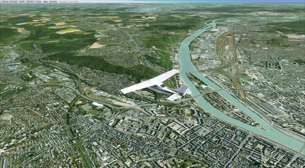 Rouen with photographic scenery |
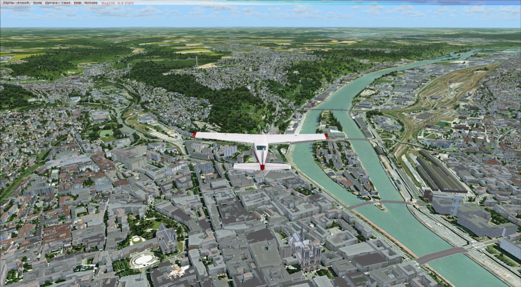 Rouen with VFR Regional Scenery |
Most of us, I imagine, have some form of photographic scenery already installed, and FVFR already covers the whole of France, it takes its high level of detail from aerial photography, so one can see detail down to individual houses.
In their latest releases FVFR combines their photographic scenery with a special technology developed by FVFR that places literally hundreds of thousands of objects all over the scenery, they do not pretend that they represent precisely what is there in reality but it gives an interpretation of what is there in the grand scale of things and I think it works well.
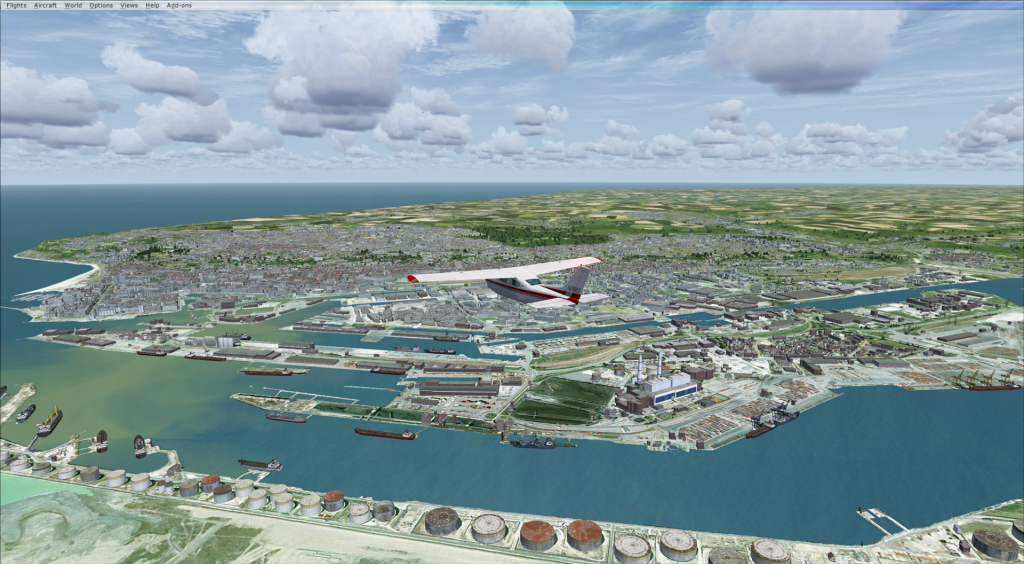
 Le Havre Photographic Scenery |
 Le Havre VFR Regional |
In reality when one flies a small a/c across the channel to France one is immediately struck by the difference in colour the villages are from the UK and the lack of urban sprawl, and this changes from region to region, in the north the general colours of houses are grey with black roofs but in the south the houses are brightly coloured with terracotta tiled roofs and the first thing I noticed with the latest releases from France VFR is that it showed exactly this. It gives much more ambience and enjoyment to the whole simming experience as well as adding a new level of realism. It is sort of like Generation X photographic scenery, on steroids.
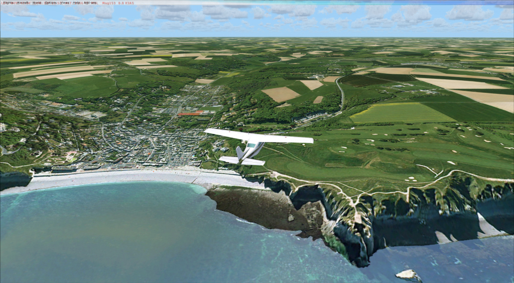 Etretat Photo Scenery |
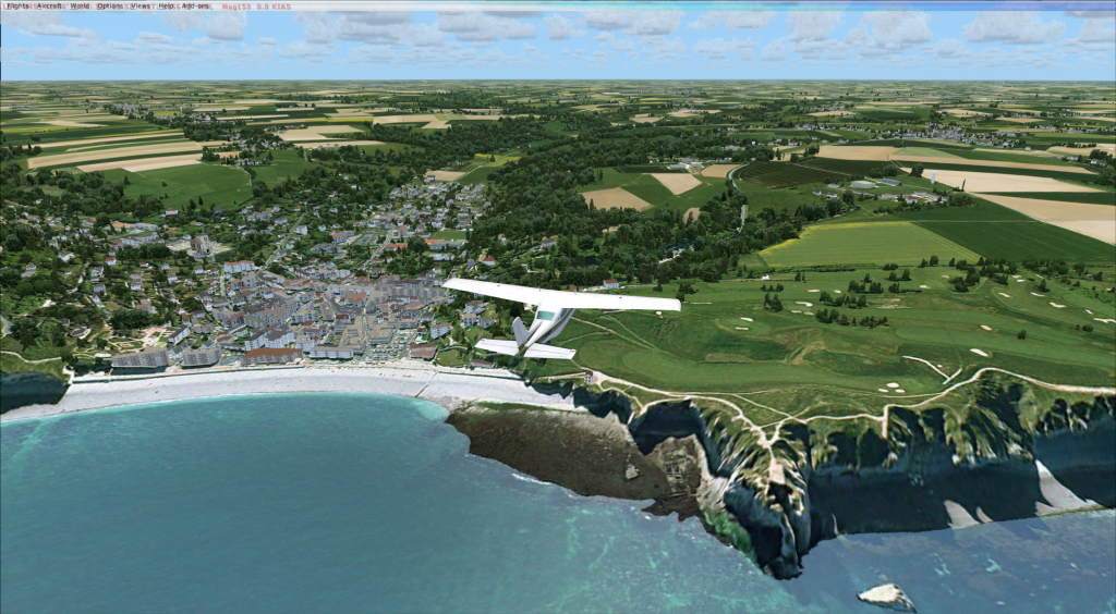 Etretat Regional VFR |
When flying to France from the UK, the majority of pilots choose one of three 3 main routes, most use the route from Dover (DVR) to Calais (ING) (less distance if walking on water becomes a requirement ) however the more seasoned use either Seaford (SFD) to Deauville (DVL) 62 miles or Southampton (SAM) to Cherbourg (MP) 77 miles.
For this part of the review I used the SFD-DVL route which arrives at the French coast at a town called Etretat, I have to say the similarity to reality is quite marvellous with the nearby fuel port and the cliffs leading down to the town and beach. I used the VFR photographic scenery which really comes into its own if you fly below 3000 feet , for those that prefer to fly airliners then the ordinary photographic scenery is perfectly adequate as that really starts to look realistic above 3000 feet, however if you are arriving at a destination that doesn't have a highly detailed airport installed all the land goes flat the lower you go, this doesn't happen with the VFR version, you land amongst 3D scenery.
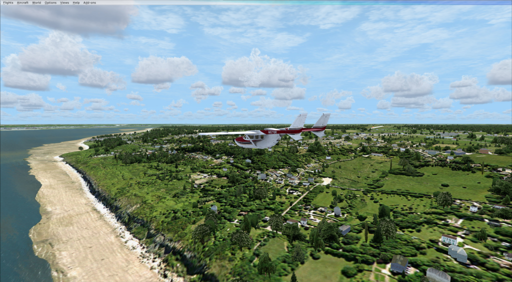 Buzzing the coast and cliffs |
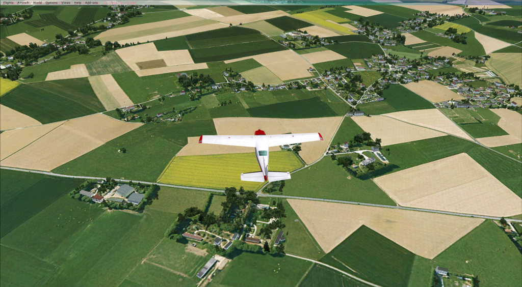 Typical Northern France, farms and villages |
I then took a tour of the Northern Normandy from Deauville to Rouen and up past Honfleur to Le Havre and followed the coast to Dieppe, an area I know very well and was again totally immersed in the flight so much so that I found what appeared to be meteor crater just south of the bridge over the Seine at Le Havre which I had never seen before so then went on to Google Earth to verify that it did indeed exist, and it did!
I then changed regions and using their latest product Alsace VFR I flew from Colmar to Strasbourg, a region I have never visited , however it was easy to get immersed again sightseeing along the river to the old town with its red roofs and on into the hills with small hamlets in the valleys, most enjoyable. In some ways these products give me, the pilot, the chance I never had when actually flying, to simply gawp outside. Yes, you did for a few seconds on the odd occasion, but when actually flying you have to be constantly aware of where you were, the proximity of controlled airspace, other a/c, weather etc. but in reality you saw nothing except a blur and the odd flash house/chateau the odd railway junction or airport, the closeness to reality this scenery gives is very satisfying.
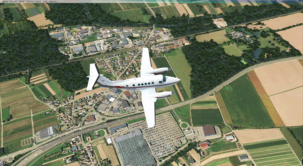
 Alsace region, note roof colours |
 Alsace Region |
The beauty of the FVFR scenery is that it covers an area 5 times the size of the UK, with spectacular mountain ranges that are 4 times higher than Ben Nevis, deep valleys that you can fly down, rivers to follow and lakes to land on. This is an enormous region to explore with loads of airfields and airports to choose from where you can take a break.
 Alsace Region |
 Alsace hills and valleys |
When it comes to performance, I cannot comment on how lower performing P.C.'s portray this scenery but the interesting thing is on my mostly 3 year old P.C.(and creaking at the seams) I have FPS locked at 30,the VFR 3d regional scenery gave a constant FPS of 30 whereas the ordinary photographic scenery gave a lower 29.9, which I found a little strange. After much testing and observation I found that I could momentarily get the fps down to 12 , but that was in a tight turn over a heavily forested hill with a highly detailed town on the shore of the sea, so not really a surprise and it quickly went back to the 30's. At any rate the fps never went low enough to cause stutters.
The Company
France VFR is small company owned and run by Laurent Dupouey formed originally back in 2003 with a couple of friends, however it soon became apparent from the demand that they had, to change their approach from a few friends earning a bit of money to a more professional approach which the friends could not afford the time to do. So Laurent soldiered on and now works with a couple of new friends as well as the odd part time freelance developer or photo processor and a few beta testers.
He is currently occupied making all the French regions “3D VFR” and shall also be producing a France VFR AI package in the near future, as well as a Europe wide mesh program, he also wants to make scenery for other countries including the UK. Sadly he has found it difficult to find a partner in the UK with whom to work. How he finds time to use FSX I have no idea as he has so many great ideas and new projects in mind. Interestingly he sees a great future for FSX for at least the next 3 years and has some scathing comments for some of the proposed replacements of FSX (more of this later). Laurent admirably retains 100% control of his products from the production of the DVD's which he makes himself to the servers where you can download his products it is all in house, so if you have a problem it is he with whom you are dealing, he has a great attitude, speaks good English, and I wish him lots of luck with his future products as he has found a nice little niche market.
Products Tested :
● Haute Normandie Photographic scenery
● Haute Normandie VFR 3D regional scenery
● Alsace VFR 3D regional scenery
The average cost of their normal photographic regional scenery is from €19-€24.90 per region whereas the much more detailed VFR regional costs between €34.90- €39.90 per region, however the “normal” photographic scenery will be phased out once the VFR regional scenery is fully online. Purchasers of the ordinary Photographic Scenery will be given preferential prices to upgrade to the new VFR 3D Regional scenery.
The main specifications are as follows:
● Ground textures from 0.85 to 1 meter / pixel resolution from IGN aerial photography reworked for an optimal visual rendition in Flight
Simulator X (Summer only).
● Dedicated mesh with high definition 4.75 meters (LOD13).
● Lakes and rivers with navigable waters fitting the texture.
● Transparency management of the seabed on the entire scene.
● Semi-detailed airports including flatten platform correction.
● Obstacles and VFR landmarks modeled on the entire scene including the official SIA database (Antennas, towers, water towers,
wind turbines, various constructions ...).
● Hundreds of thousands of objects and notable buildings integrated into the environment (Churches, power plants, silos, castles,
industrial tanks, bridges, tolls, cranes, boats, streetlights, road signs ...).
● Integration of 3D Automation® technology allowing multi-million buildings and realistic vegetation areas fitting geographic specs.
● Extremely dense and optimized vegetation coverage using a custom rendering module controlled by artificial intelligence (AI).
● Autogen buildings including additional specific and optimized 3D variations.
● Geo-referenced data for maximum compatibility with future add-ons installed on the same area.
● Development process 100% Microsoft SDK specifications compliant, ensuring maximum compatibility with new releases.
 Le Havre in "3D" |
 Approaching Dieppe |
FVFR suggests that computers should have a minimum of 2gb of memory and at least a graphics card with 1 gb of memory however for optimum results 4gb of memory and 2gb of graphics memory are really required.
All the Photographic and VFR scenery products are available by fast download and payments made via a secure pain free process. The installation was totally trouble-free However be warned if you have a slow internet connection as the files can be several gigabytes in size so can take some time to download. DVD's of the VFR Regional scenery will be available see their website for details.
Documentation:
I was very pleasantly surprised by the amount of documentation that accompanies each region, you not only get installation instructions as well as configuration advice, but a technical explanation and FSX settings advice as well. And if that was not enough they have supplied all the airport approach plates for the airfields in the region, plus copies of the official VFR rules of the air, as well as IFR rules (all in English as well as French and also a very handy map showing low level controlled airspace, airways and reporting points to use when crossing from France to other countries and lastly a map of upper airspace showing all the airways etc. Superb!!
A few other developers should take note!
Conclusion
In conclusion I have to say these products have everything to recommend them. They make a welcome and huge improvement over the stock FSX scenery even with GEX installed, and takes "cooking " photo scenery, at least one level higher, in my opinion. It totally transforms the VFR simming experience making it much more immersive, you can literally get lost for days bumbling around this vast countryside wondering what will appear around the next mountain or river bend, there are times it looks SO realistic. The only downside that I can see, per se, is the size of the investment one would have to make if you want to have all of France covered, as there are 22 regions! but having said that the FVFR scenery compares favourably with the competition on price.
A minor point but, I do wish that more of their website was available in English as I am sure this would encourage much more foreign custom and allow their name to be as well known as it deserves. People nowadays are shy enough to put credit card details on any internet site regardless of how secure it appears, having to do that in a foreign language site requires a bit more faith than normal I am sure FVFR would profit from making this extra effort..
| Verdict: |
 |
|
| • Level of Detail: | 9.5/10 | |
| • Performance: | 9.0/10 | |
| • Scenery Coverage: | 9.0/10 | |
| • Quality of buildings: | 8.0/10 | |
| • Documentation: | 10/10 | |
| • Value for money: | 8.0/10 |
| Mutley's Hangar score of 8.9/10 - Highly Recommended |