Introduction
and a bit of History
Los Angeles - (City of) The Angels - the second most populous
city in the U.S.A., after New York, and known to everyone as,
simply, L.A. Originally founded as a mission in 1781, the pueblo
La Reyna de los Angeles slowly grew into a ranch town under
Spanish, then Mexican rule, which ended in 1847 when California
became a U.S. Territory. Since then, L.A. has expanded and now
has nearly 10 million people living and working within its
county boundary - a population bigger than 44 individual U.S.
states!
To most of us, L.A. is the home of Hollywood and Walt Disney,
but it is also the focus of international trade through its
ports, which handle more than 25% of the container traffic
entering the U.S. L.A. also boasts the highest (AGL) helipad in
the world on top of the U.S. Bank Tower (310m/1018ft), which
brings us conveniently to the Aerosoft L.A.-X Scenery, which,
combined with detailed photo-scenery renditions of 16 of L.A.'s
local airports, boasts a total of 143 its city's helipads! Read
on to find out more...
Download and Installation
At 2.33 G-bytes, the Aerosoft-U.S.-Cities-Los-Angeles-FSX is a
fairly hefty download, so, if your connection speeds aren't the
fastest, you may have to resort to an over-night download.
Subsequent installation is straightforward with the requirement
to enter your purchase registration details, which is sent via
email after payment has been processed. Prior to installation,
however, you will need to refer to the manual (available free
from the Aerosoft website) and establish the level of scenery
density your computer will support. Once you know this, you can
proceed with the installation of the scenery.
As with other Aerosoft scenery products, your US Cities - Los
Angeles will be placed in a separate 'Aerosoft' folder within
FSX rather than in the FSX\Add-on Scenery folder. The new
scenery takes up 2.66 G-Bytes of disk space. After you've
checked this, you're ready to fire up FSX. Once it is running,
you will need to adjust several of the FSX settings for
Graphics, Scenery and Traffic - the latter is particularly
important. Another look at the Manual is mandatory at this
point, otherwise you may suffer with poor frame rates - you have
been warned!
Exploratory Flight around the
Los Angeles Area
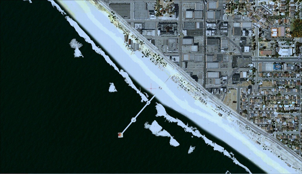
| Normally, once a new add-on is installed, I would throw caution to the wind and just jump into my favourite helicopter and, well, take off. But with an area approaching 2,000 square miles, the Aerosoft L.A. scenery really requires a more systematic approach, so a flight plan was appropriate, I thought. A good starting point would be Catalina Island's "Airport in the Sky" (KVAX), where the manual boasts a sloping runway and full rendering of the whole of the island. Next, I wanted to go to Disneyworld in Santa Ana, via John Wayne airport (KSNA), followed by the Queen Mary at Long Beach. Up the coast to Santa Monica and Malibu before crossing the hills into the San Fernando Valley, for Van Nuys (KVNY) and Bob Hope (KBUR) airports. Hollywood next - The Bowl and, of course, The Big Letters, before heading to Downtown L.A. via the Dodger's Stadium. Here's the plan from Tim Arnot's Plan-G: | 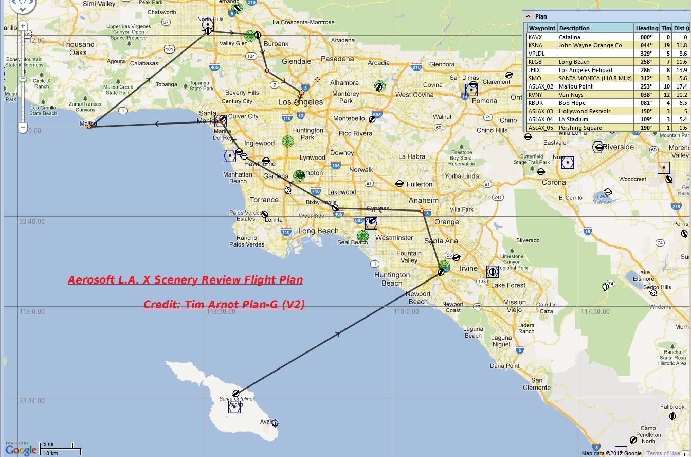
|
With all those helipads to investigate, it had to be a helicopter - Surprise, Surprise! But with frame rates in mind, I chose the default Bell 206B JetRanger, rather than a more complex model. Selecting an early afternoon take-off, I found myself at KVAX, together with a number of tourists and their G.A. aircraft. Soon I was in the air above KVAX and following the coast, southwards down the eastern coast of Catalina towards Avalon. KVAX is very realistically executed, particularly the runway's 'blind summit'. The island terrain is quite spectacular - with ravines and gullies, and small bays along the coast. The photo-based ground texture is populated with plenty of scenery objects - houses, sheds, cars and boats - making the island feel inhabited. The port of Avalon, where most of the tourists to the island arrive by ferry, is neatly depicted, with the Casino on Sugarloaf Point and the harbour full of yachts.
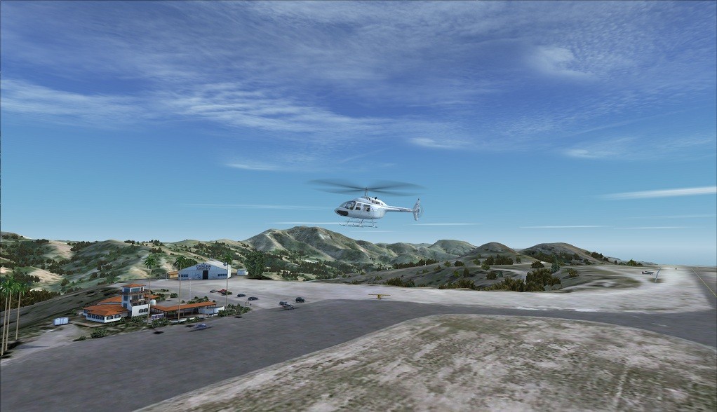 Catalina Airport |
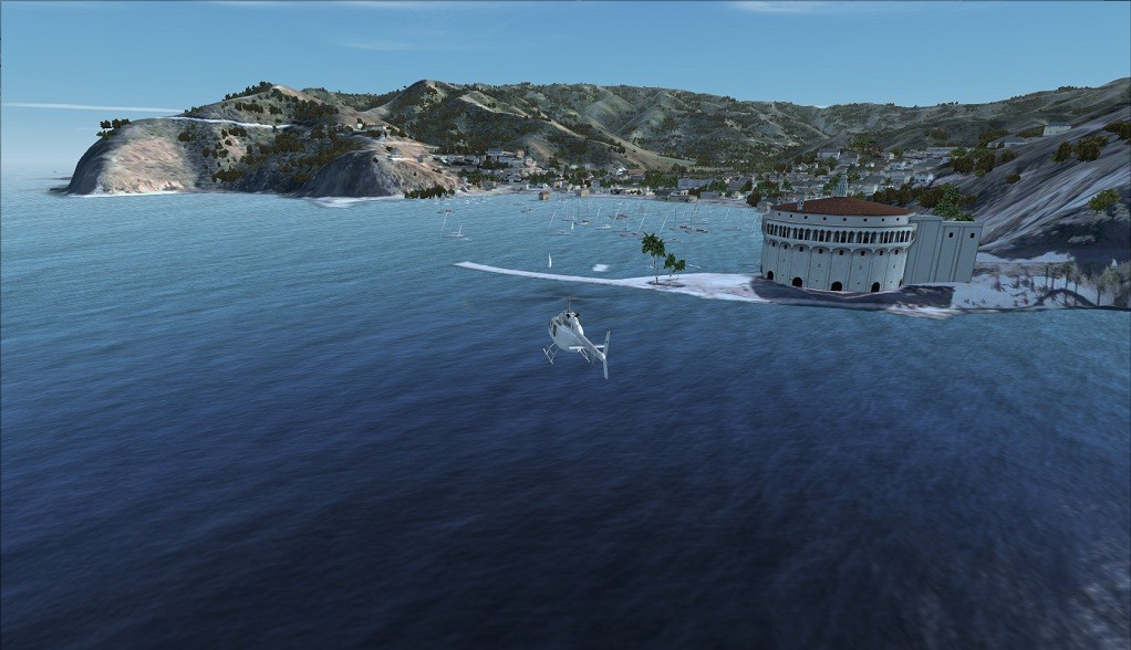 Avalon Port |
Just south of Avalon is Pebbly Beach, where there's a sea-plane base and power station, and where I found one of Island Express Helicopters' heliports - their other heliport is at Long Beach, by the Queen Mary Hotel. The heliport at Pebbly Beach look very good, but parts of Pebbly Beach don't achieve this high standard, particularly some of the power plant buildings, which look more residential than industrial.
 Pebbly Beach |
 Pebbly Beach Heliport |
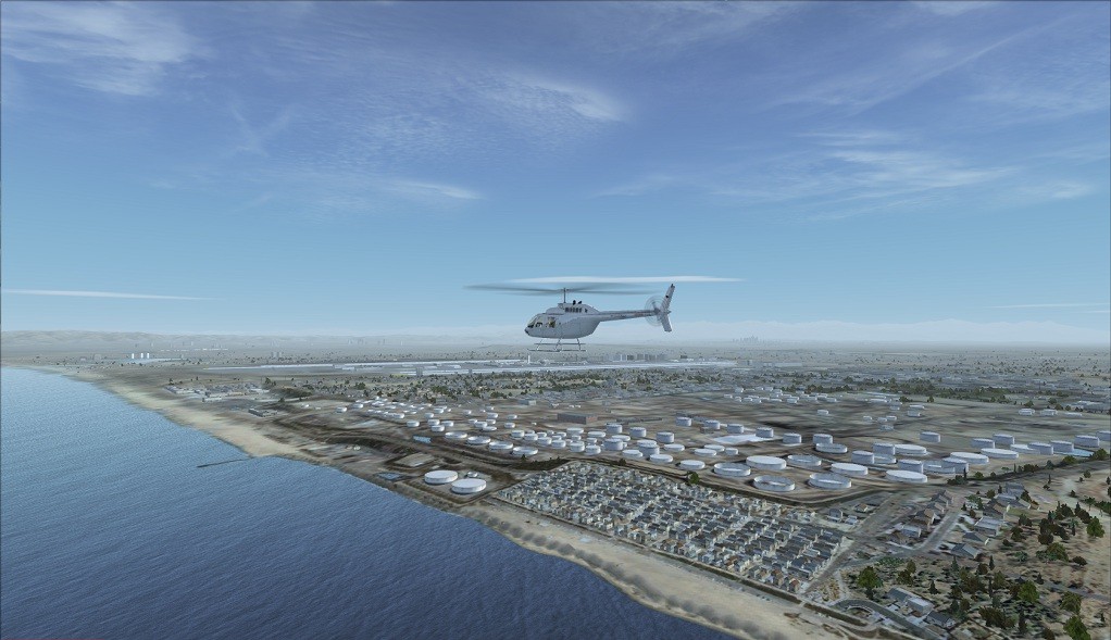
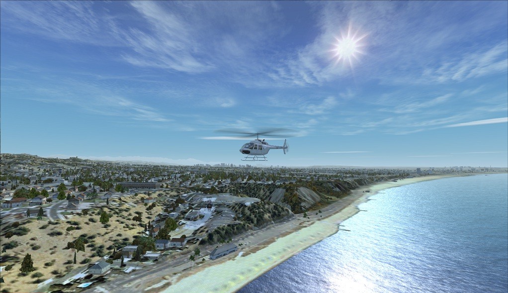
From Avalon, I headed east towards the mainland, some 25 nautical miles away. Landfall was at Huntington Beach, home of, possibly, the most famous pier in the surfing world, but I was disappointed to find no appropriate scenery object and some rather basic default suburban scenery inland of the beach.
 Huntington Pier |
 Huntington Default Ground Texture |
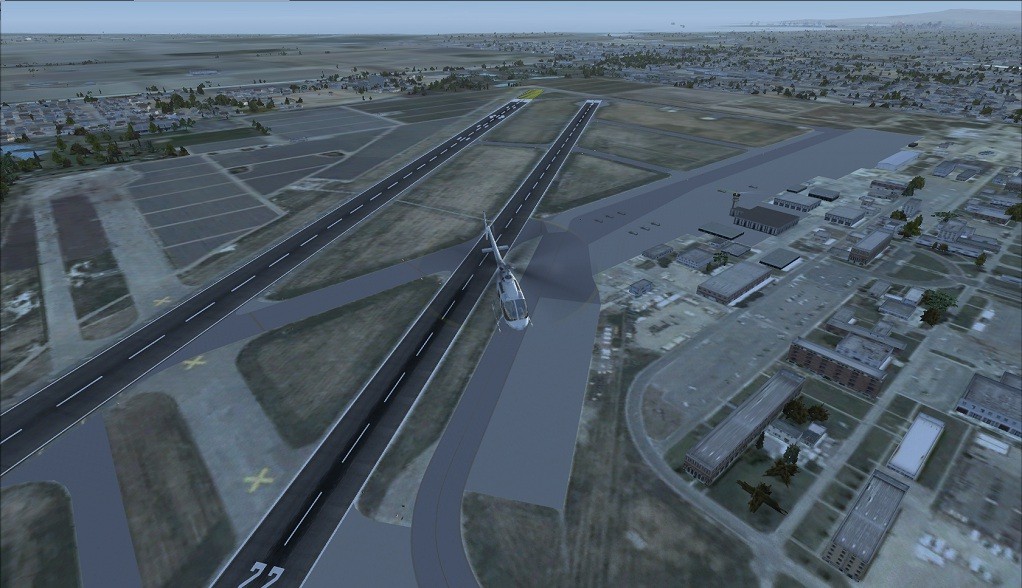
On, towards John Wayne airport, the first major airport I was to visit, and a pleasant surprise! The airport and the surrounding area is built up from photo-real ground textures, and virtually every building is present, which makes the simulation almost completely immersive. Whilst, on closer inspection, some of the buildings correspond more to a retail park than an airport, the overall effect is quite convincing. While circling KSNA, I noticed some large buildings about a couple of miles north-east. On closer inspection, I found the now disused NAS/Marine Corps Air Station, Tustin (KNTK) and its enormous hangars, which housed the U.S. Navy's airships, or Blimps during and after WWII, after which it became home to the helicopters of the Marine Corps. Most recently, the hangars have been used by Hollywood movie makers but, sadly, Tustin is destined to re-developed for housing and business use.
 John Wayne KSNA |
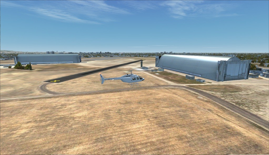 Tustin KNTK Ex NAS Airship Base |
Turning north-east, it's about 6 nautical miles to Anaheim and the Disneyland Theme Park. Here I was to find Walt's treasure trove: Sleeping Beauty's Castle, Magic Mountain and Mickey Mouse's Ferris Wheel. From around a thousand feet, the place looked quite the adventure it's made out to be - the simulated view being as good as a visit to the real thing, if you ask me!
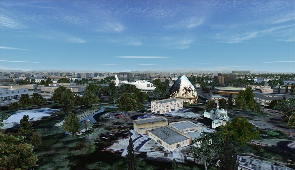 Disneyland Magic Mountain and Sleeping Beauty Castle |
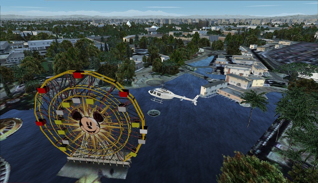 Disneyland Mickey's Ferris Wheel |
A short time after turning west, towards Long Beach, I was passing over Los Alamitos (KLSI), which started as a Naval Air Station during WWII, before becoming an Army Airfield shortly after the end of the Vietnam War. Several military helicopters were visible on the ramp, by the main buildings. A couple of minutes later, I was at Long Beach (KLGB), looking down on the site where Douglas had manufactured so many DC-3s and C-47s. No longer required by Boeing, who took over McDonnell Douglas in the 1990s, the factory buildings have been demolished and the site is to be redeveloped. Under the name Douglas Park, it is destined to become a retail and business centre.
 Los Alamitos AAF KLSI |
 Long Beach KLGB Douglas Park |
In the distance, I could see Long Beach's renowned dockyard, a naval base until closure in the 1990's, and now home to one the world's most famous ocean liners, the R.M.S. Queen Mary. As I approached the coast, the outline of the ship came into view, as did several rooftop helipads. After a few minutes of landing practice, I re-focused on the Queen Mary and had a closer look. In her retirement, she has become a hotel and is permanently docked.
 Long Beach Helipad Practice |
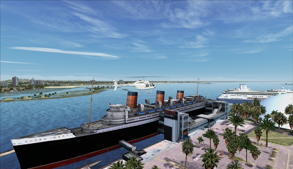 Long Beach Queen Mary Hotel |
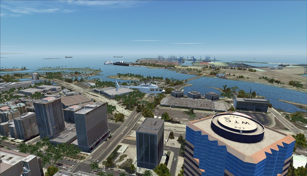
Just round the corner, past the modern cruise liner, I found Island Express Helicopters' mainland heliport. Another neatly executed set of scenery objects and high resolution ground textures. I landed here to take a break and have a bite to eat in their cafe - and the hamburger didn't cost 100 dollars!
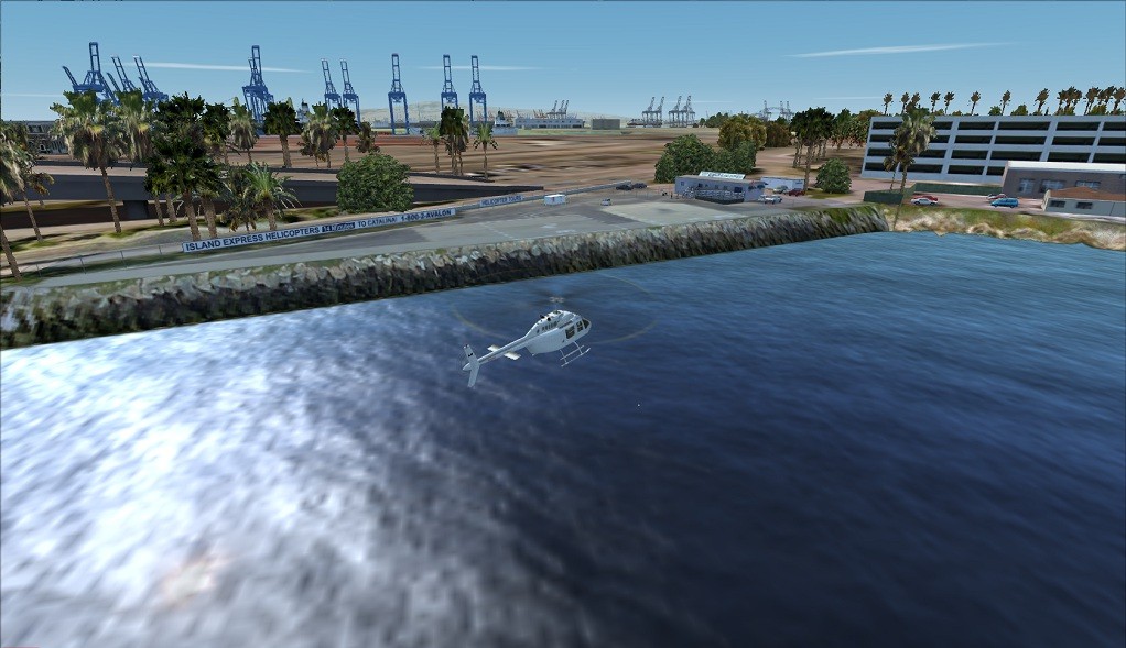 Long Beach Queen Mary Heliport |
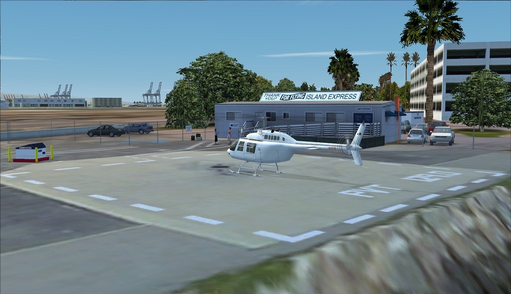 Long Beach Island Express Heliport |
Refreshed, it was time to continue up the coast towards L.A.'s main airport, KLAX. At the north end of the dockyard, I came to the Vincent Thomas Bridge, with its high span to allow merchant ships uninterrupted passage. Before reaching the coast, I passed Zamporini Torrance airport (KTOA), where Robinson helicopters are produced in the factory at the south end of the main runway.
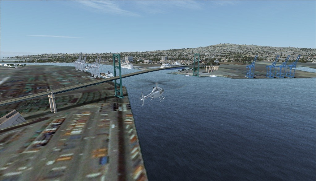 Long Beach Vincent Thomas Bridge |
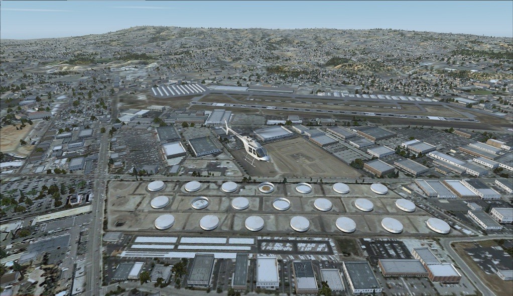 Zamperini Torrance KTOA |
I picked up the coast at the southerly extreme of Manhattan Beach, where there is yet another marina. Following the sands northward, I soon came to the fuel depot for KLAX and my first glimpse at this huge international airport, which, according to Wikipedia, handles more "origin and destination" (i.e. not connecting) passengers than any other airport in the world! With its 4 runways and 9 terminals, I can well believe it.
 Manhattan Beach Marina |
 KLAX Fuel Storage |
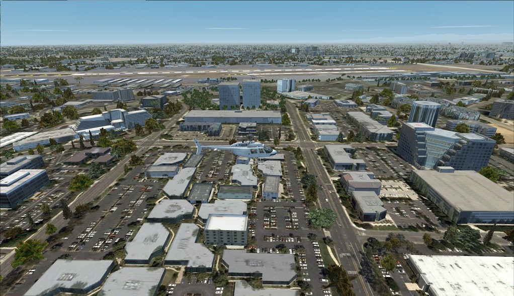
As I flew over the main airport buildings, I was very impressed with the level of detail exhibited by the scenery objects. As with the other airports I had seen, thus far, the KLAX scenery blended with the ground photo-textures extremely well. This detail extended well beyond the perimeter of the KLAX field and included hotels, industrial buildings as well as highways.
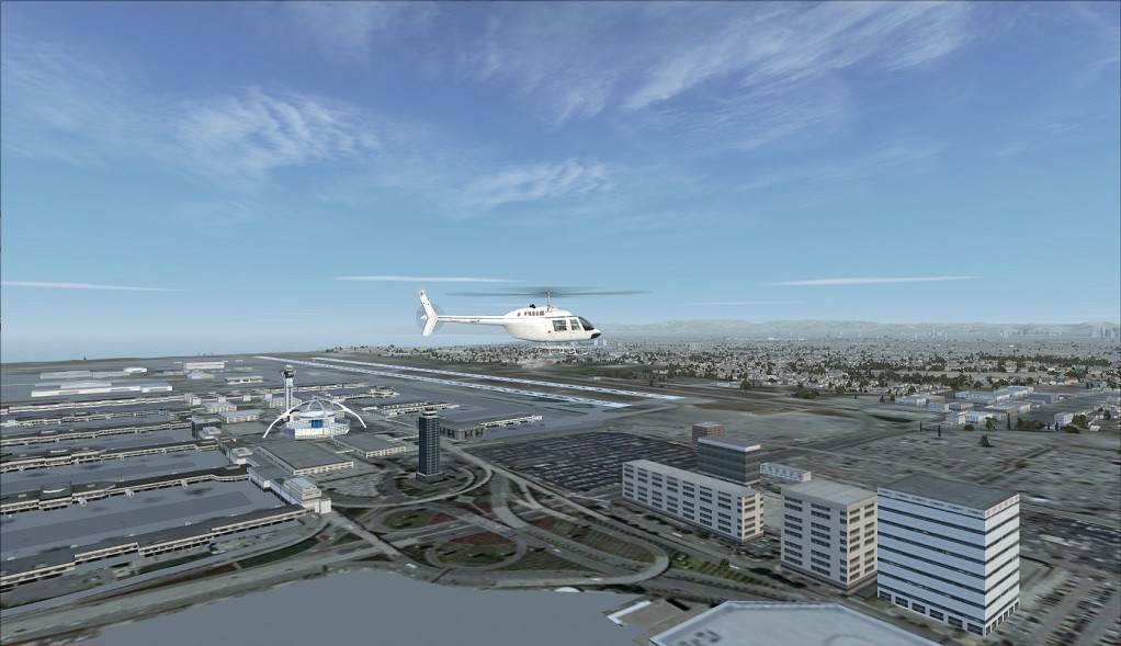 KLAX View |
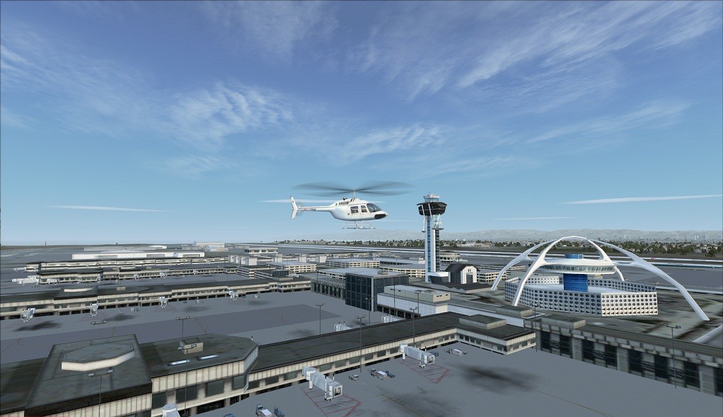 Main Buildings |
Just north of KLAX is the large Marina Del Rey and further on, after flying over Venice, I came to Santa Monica airport (KMSO), or Clover Field, as it was originally called when Donald Douglas started his famous company back in the early 1920s. Douglas took over a disused building that had been used for movie making, and, since aircraft manufacturing no longer takes place here, it is ironic that several of the hangars are now used by, yes, you guessed, the movie industry!
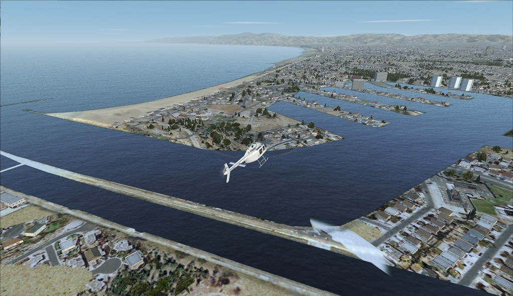 Marina Del Rey |
 Santa Monica KSMO |
Westwards, again, brought me to the coast at Santa Monica beach, with its pier, complete with Ferris wheel and roller coaster. A couple of miles north of the pier, the beach ends and the Pacific Palisades start. Here, the road by the beach becomes the West Pacific Coast Highway, as seen in so many movie car chases. As the default scenery took over, it was time to climb up and over the Topanga Hills to reach the San Fernando Valley.
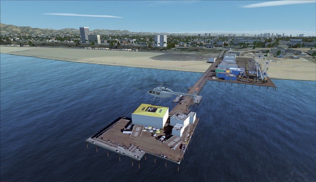 Santa Monica Pier |
 Santa Monica Beach North Point |
Following the Ventura Highway back eastwards, Van Nuys was the next airport to visit.
 Turning Off Ventura Freeway |
 Van Nuys KVNY |
Just a couple of minutes further east and I was coming up to Bob Hope airport (KBUR), formerly Hollywood-Burbank before being named for the famous comedian. As I was leaving the field, I noticed some earthworks to the north. On inspection, these turned out to be part of the Sun Valley Recycling Facility, a politically correct version of rubbish dump.
 Sherman Ave To KBUR |
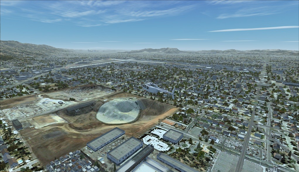 Sun Valley Recycling Facility |
Leaving Burbank, I flew southwards towards the gap in the Hollywood Hills, with downtown L.A. beyond. I passed over the Hollywood Reservoir before turning east again at the Hollywood Bowl. Here, on my left, were the world famous letters, spelling out the area's name.
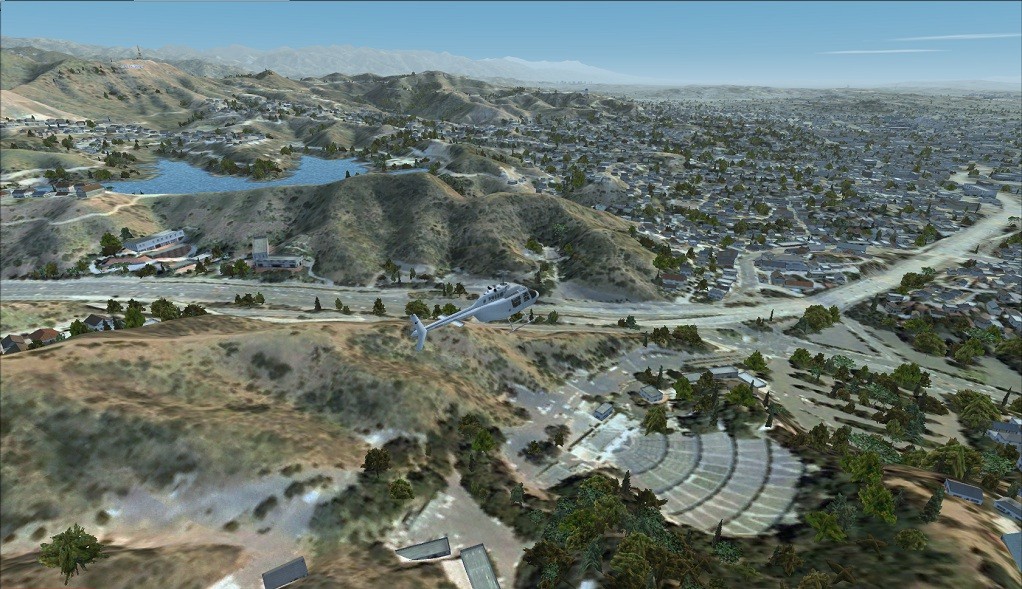 Hollywood Bowl And Reservoir |
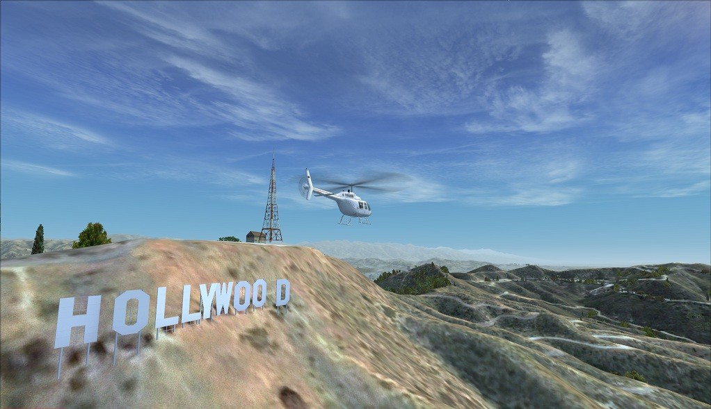 Hollywood Hills Sign |
Not too far away was the Griffith Observatory, with its commanding views over the city. Then I followed the Golden State Freeway down towards the Dodgers' Stadium.
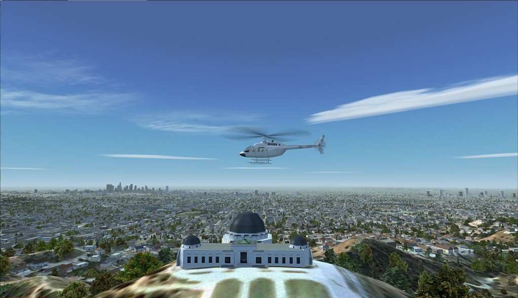 The Observatory |
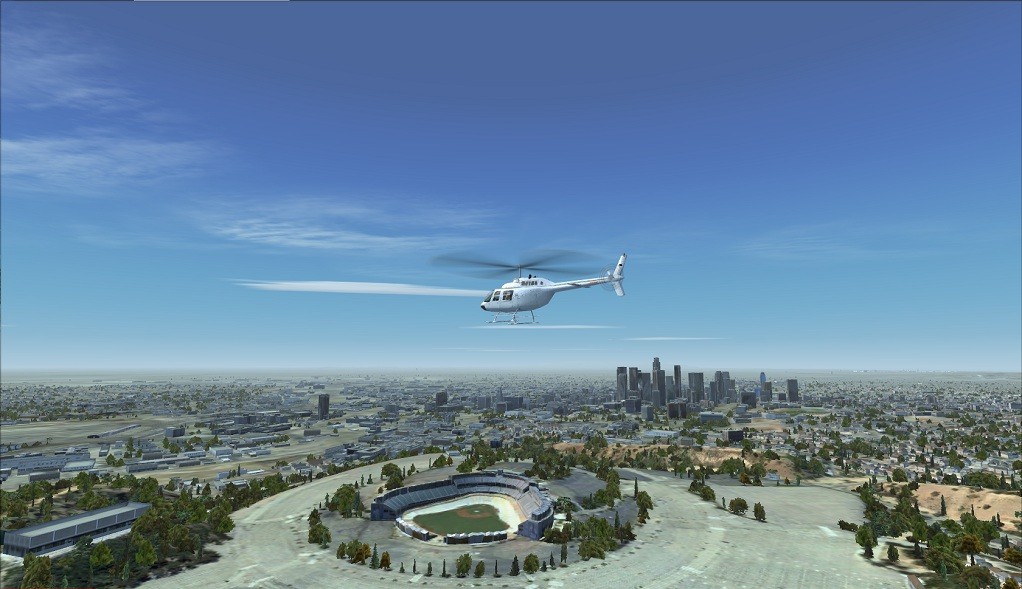 The Dodgers Stadium |
Picking up the L.A. River and following it downstream to the Santa Ana Freeway overpass, where I came to the main LAPD helicopter facility at the Hooper Heliport. Landing there, I found nearly all the helipads occupied with LAPD AS350s - a tribute to the Eurocopter sales team!
 LAPD Hooper Heliport |
 LAPD Hooper Heliport Apron |
After a quick look around the LAPD's maintenance area, I took off in the direction of the downtown skyscrapers. Luckily for me, the over-head power-lines, near the heliport, were festooned with brightly coloured balls - a valuable safety feature! Turning west, I headed for the Staples Centre, where the downtown towers appeared to rise up.
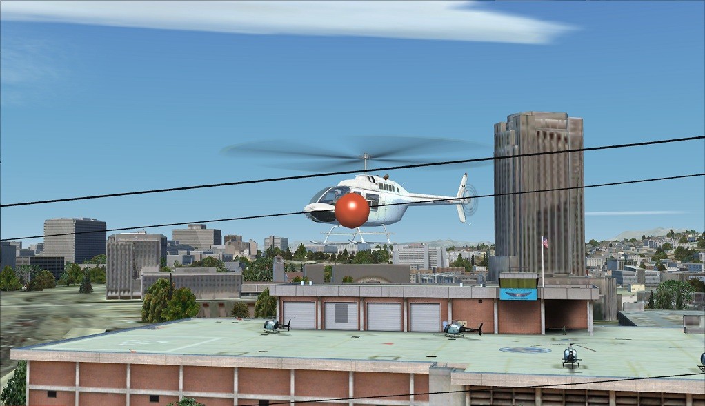 Aerial Obstacles |
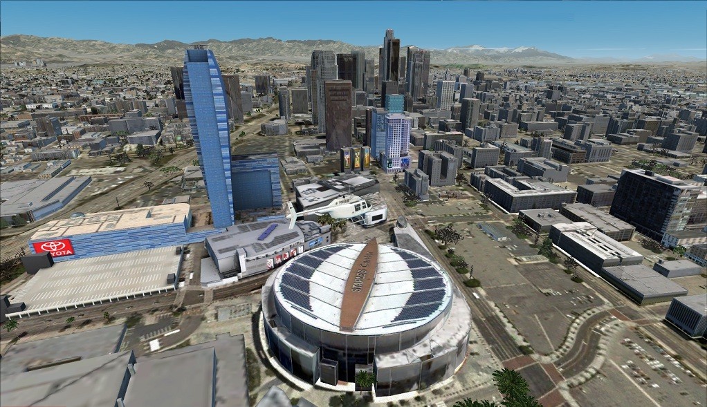 South Downtown LA |
I remembered reading in the Manual that L.A.'s Zoning laws require every building taller than 75 feet to have an emergency helipad. And I could now see that every one of these helipads had been replicated - a brilliant opportunity for more landing practice. As I flew over the cityscape, the scenery objects seemed to match the ground textures quite seamlessly, giving a most immersive effect. I did notice, however, that my frame rates were dipping, but not to such a level that impeded controlling the default 206B. In fact, I managed to make a comfortable landing on the U.S. Bank Tower helipad to complete this rather extended tour.
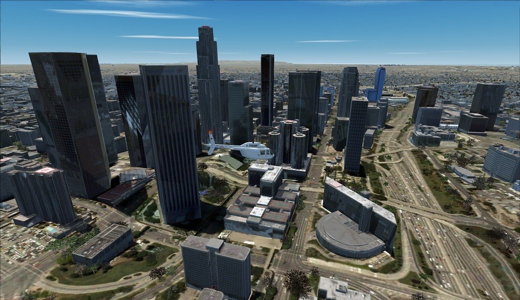 North Downtown LA |
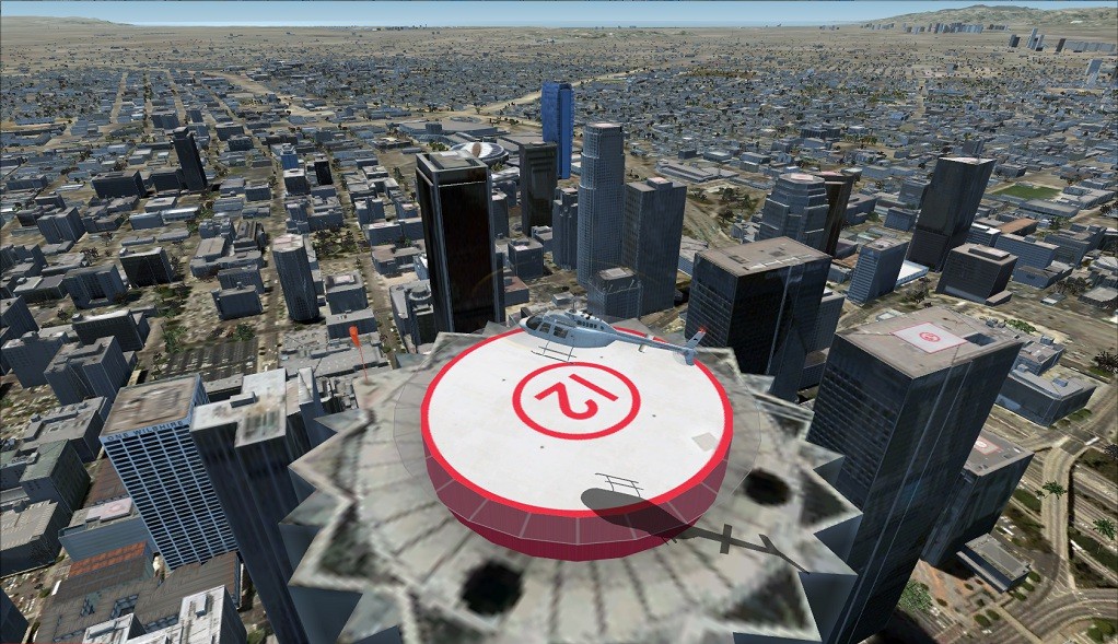 US Bank Tower Helipad |
First Impressions
I've got to come clean and say that my very first impression of US Cities Los Angeles wasn't too good. And that, I'm afraid, was because I hadn't read the Manual - particularly the details about Traffic Settings. I did try both levels of scenery complexity with the supplied Scenery Density Tool, but didn't really notice any difference. However, once I'd selected zero percent for Road Traffic in the FSX Display Settings, I found that the stuttering stopped and that my frame rates went up to an average of around 20 F.P.S, which is acceptable for me as I rarely go above 100 knots in flying virtual helicopters. As you can see from the review system specs, my set-up isn't the best. If yours has a higher rating, then you'll probably be able to enjoy a reasonable amount of traffic on your highways.
So, what were my thoughts after the exploratory flight, detailed above? Well, I'm honestly impressed. I've never been as far west as L.A, but after flying just the once around the area, I found myself liking the scenery as well as the city itself. L.A. is certainly a big place, with a lot of diversity. I really enjoyed putting a face, as it were, to places that I had only heard or read about. Whilst I knew a little about the history of "Tinsel-Town", I was unaware of L.A.'s other industries. Seeing where Douglas had built my favourite fixed-wing aircraft, the DC-3, was a real bonus, as was discovering where Robinson Helicopters are still being made.
I liked the way the photo-based ground textures and scenery blended into the default scenery, and in the suburbs, I could not really tell them apart. Where it was obviously photo-based, like at the airports and in downtown L.A, the scenery object placement was nearly perfect, and the resulting simulated view most realistic. In places around the airports, the building textures were more reminiscent of a retail park than storage and light industrial, but this was only noticeable if you looked closely. Also, there were areas, like the Marina Del Rey, which had been left as default and stood out because of this. And the omission of certain scenery objects, like the pier at Huntington and the stage at the Hollywood Bowl, was disappointing. However, in the main, the specially developed scenery objects, like the Hooper Heliport and the R.M.S. Queen Mary, more than compensated for these omissions.
As all the included airports are based on photo-based ground textures, they are an immense improvement on the default fields, especially the additional apron details, jet blast deflectors and ancillary buildings. L.A. International (KLAX) looks very realistic but rather empty as I had to set both airline and G.A. traffic to low values as per the recommendations in the Manual. Sheperd Field (CA24) was the only exception to this as, whilst the manual says "Closed! Removed from the scenery!” in my installation the default runway still appeared in between the houses of the 'newly built' housing estate!
So, some very good points and some, perhaps, not so good - let's go into more detail...
Detailed Assessment
Aerosoft's U.S. Cities-X Los Angeles covers almost half the area of L.A. County - that's upwards of 2,000 square miles (5,180 square kilometres). Now, not all of this area has photo-based ground textures, but the figure is possibly between 10 and 15 percent (200 to 300 square miles or 500 to 800 square kilometres). In the photo-based areas, the scenery objects have been placed very accurately. Although some of the building objects may not be the best choice, the overall effect is really good. The remaining (85 to 90%) area uses the standard FSX default ground textures and auto generic scenery objects. The interface between the two ground texture types has been carefully implemented so that it's virtually impossible to see the 'join'.
Looking at the level of detail in the photo-based areas, I have to say that some are quite excellent, whereas others are not so good. For example, Santa Catalina airport and all three heliports are well executed, with high definition ground and model textures, giving an immediate effect of 'being there'. Also, the finely detailed modeling of the R.M.S. Queen Mary and the Vincent Thomas Bridge provide an excellent backdrop to virtual flying. Whilst many of the high rise buildings in downtown L.A. are also of this high standard, some, particularly the buildings with glass facades, have a rather low definition look about them. Unlike the textures on the KLAX Control Tower, the downtown glass facade building textures are not reflective. This may be due to their adverse frame rate effects. Unfortunately, the lack of reflection ruins the buildings' authenticity. Also, many of the other 'non generic' buildings in the city have a rather 'blocky' appearance. O.K, you are 'flying' over them, but you can't but help looking at their lack of detail and this can reduce that all important immersion factor.
As I mentioned before, I had some trouble with performance before realising I needed to reduce the Road Traffic Display Setting to zero. If any of you fly virtual rotorcraft on a regular basis, then you'll know that stuttering can make controlling your helicopter almost impossible. Any dip below 15 F.P.S. can result in an unrecoverable state, so it's most important that your system can accommodate the complexity of the L.A.-X scenery. As I said, I found changing between the 2 levels of scenery complexity made little difference to my system's performance. It seems to me, at least, that the Road Traffic adjustment had much more effect.
On the specific question of the Scenery Density Control Tool, it's disappointing that the developers didn't use the same mechanism for adjusting scenery density as some others, who utilised the feature that system performance can be improved by reducing the Display Settings>Autogen Density function within FSX. However, unless this option was incorporated into the design process at a very early stage, I guess it was not possible to include at the point where user system performance problems were encountered. Lastly, and this is a detail really, there is an inconsistency between the user system requirements as stated in the promotional material, on Aerosoft's website, and that given in the Manual. In the former, a 500 M-byte GPU plus Core-2 Quad processor is recommended, whereas in the Manual, a 1024 M-byte GPU plus i5 processor is advised.
Sound Effects and Animations
The sound effects that come with the L.A. scenery include highway and city traffic together with cawing seagulls. Although these effects are not intrusive, it can be unnerving to hear sounds of water lapping when you have just landed on a helipad more than a thousand feet high! But, as the manual says: "If you don’t like this, just go to Settings -> Sound and decrease the environment sound volume".
The AI boats certainly give the scenery a feel of a living, if virtual, world. The only truly animated scenery object I found was on the roller coaster at Santa Monica Pier, but, knowing LimeSim and Aerosoft, I suspect there are others!
PDF Manual
The Manual is short and well laid out. It includes basic information about the area, its airports and the 143 helipads/heliports included with the scenery. There's a comprehensive section on compatibility issues with other scenery add-ons, should you already have some or all of these installed. A section dealing with Frequently Asked Questions addresses many installation difficulties. For me, the most valuable section related to Display Settings and how to get the best performance out of your system. As I said above, you must read this section if nothing else.
One thing the Manual lacked, however, was a map. A diagrammatic representation of the photo-ground texture areas and add-on scenery object coverage would be a useful reference.
Pluses and Minuses
Make no mistake, I have really enjoyed flying around L.A. with this Aerosoft scenery. Certainly, the airport areas are a huge improvement on the default and the heliport modeling makes landing and taking off as immersive as it gets. From a rotorcraft fan's point of view, the inclusion of so many high building helipads is a fantastic opportunity for practicing raised platform landings, something I never tire of. Add to that, the facility to visit famous places of historical interest, particularly the film and aviation industry, is quite a bonus.
On the down side, I did find some of the scenery objects' lack of detail reduced the immersion factor. This, together with some areas of quite inappropriately looking default scenery, like the Marine Del Rey, also detracted from my enjoyment to some extent.
The Manual points out that as this scenery add-on is "Fully aimed at daytime VFR flights, it does not include seasons and night textures." Aerosoft have priced the L.A. scenery at Euro 20.00 (21.99 USD and GBP 16.06), which I think is extremely good value for money. Flying helicopters at night in a non-military theatre is not my preference, anyway, so I'm happy with this limitation. As for seasonal variations, with an average minimum temperature in January of 45°F (7°C) and an average maximum temperature of 90°F (32°C) in August, only marginal changes in ground textures would be expected.
Concluding Remarks
The U.S. Cities Los Angeles scenery gives you a really good opportunity to discover the various scenic delights of L.A. and its surrounding area. Although I found it somewhat of a challenge at first, I ended up enjoying the experience, as I'm sure you will too. So, if you've a mind to visit L.A. either in the real or virtual world, this add-on scenery from LimeSim and Aerosoft would be a worthwhile investment.
![]()
Verdict
![]()
|
• Scenery Coverage: • Level of Detail: • Performance: • Scenery Density Control: • Sound and Animation: • Documentation: • Value for Money: |
8.0/10 7.0/10 7.5/10 6.0/10 8.0/10 8.0/10 9.0/10 |
Final Mutley's Hangar Score 7.5/10
David Williams
Review machine Spec: Q9400 2.67 GHz |
4Gb Ram |nVidia GeForce 8800 GT 512 Mb |Windows 7 64bit
 |
System Requirements
|
|
|
|